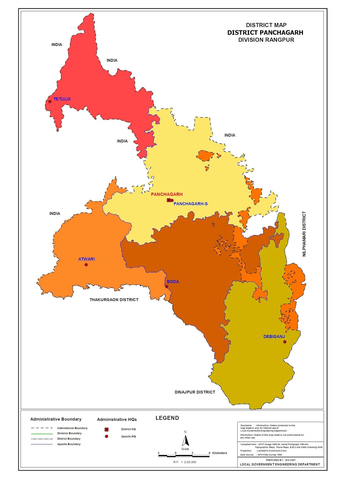
Administration
of Panchagarh District
Panchagarh (Bengali: পঞ্চগড়, Ponchogorh, means five forts) is a district
of Rangpur division in the extreme northern part
ofBangladesh with
an area of 1404.62 square km,[1] is
bounded on three sides by 288 km long Indian border,
having Darjeelingdistrict on the north, Jalpaiguri and Cooch Behar Districts on the northeast, West Dinajpur District and Purnea district
on the west.Dinajpur and Thakurgaon Districts on the south, Nilphamari District on the east. Its soil
is sandy, alluvial and bears close affinity with the soil of the old Himalayan basin.
On the northern part of the district there exists underground layer of pebbles. It is 150
feet (46 m) high from the sea level. Panchagarh has 16 rivers. Among them
some main rivers are Karatoya, Atrai, Tista, Nagor, Mahananda, Tangon, Dahuk,
Pathraj, Bhulli, Talma, Chawai, Kurum, Versa, Tirnoi, and Chilka.
Administration
Administrator
of Zila Porishod: Abu Bakar Siddique[2]
Deputy
Commissioner (DC): Muhammad Salah Uddin[3]
Members of
tenth Jatiyo Sangsad
Panchagarh-1:
Nazmul Haque Prodhan [from Jasod]
Geography
Panchagarh
is the situated in the north side of Bangladesh. It is 150 feet (46 m)
high from the level.
|
Description
|
2011
|
2001
|
% of
National
|
|
Area(km2)
|
1,404.62
|
1,404.63
|
0.96
|
|
Population
|
10,26,141
|
836,196
|
0.71
|
|
Description
|
2011
|
2001
|
1991
|
%
change
|
|
Density
|
703
|
595
|
507
|
17.36
|
|
Literacy
rate
|
51.8
|
40.82
|
27.80
|
46.83
|
Total
Boundary: 302.68 km
Estublished:
01.02.1984
No. of City
Corporation: 2
No. of
Upzilla: 5
No. of
Union: 43
No. of
Village: 825
No. of
Mouza: 463
Rate of
education:
Men: 42%
Women: 24%
No. of
Rivers: 16
Main Rivers:
Korotoya, Dahuk,Chawai, Tirnoy.
Rivers:
Panchagarh has 23 rivers. Among them some main rivers are Karatoya, Atrai,
Tista, Nagor, Mahananda, Tangon, Dahuk, Pathraj, Bhulli, Talma, Chawai, Kurum,
Versa, Tirnoi, and Chilka.
History
The
existence of five garhs (fortifications) has hitherto been traced, of which the
most noted are Bhitargarh, Hosaingarh, Mirgarh, Rajangarh and Devengarh.
Panchagarh is named after these five garhs. Here Panch stands for five. (need
to be edited)
Culture
In pohela
boishakh, the first day of Bengali year, boys-girls and all section of people
play with color water (similar to Holy in India) in every road.
Transport
Bi-cycle,
rickshaw, motor cycle are the main modes of transport for the local people.
Regular buses connects the district to their neighbor districts and
subdivisions. The road distance from Dhaka (Capital city of Bangladesh) to
Panchagarh is 475 km. Road transportation between Dhaka & Panchagarh
is a private sector affair operating predominantly in domestic routes.
Education
B.P (Bishnu
Prasad) Govt. High school which is located near the Panchagarh Town,is the
biggest and most famous boys' school of Panchagarh and the S.S.C examination
(public exam) result of the school is very good. In 2009, 85 students of this
school got GPA 5 in the SSC examination. Panchagarh Govt. Girls' High School,
which is situated at the heart of the Panchagarh Town, is the most famous
girls' school of the district. In 2008 SSC examination, 32 students of this
school got GPA 5 in the SSC examination. M.R (Moqbular Rahman) Govt. College is
the biggest and most famous college of Panchagarh while Panchagarh Govt.
Women's college is the most famous women's college of the district. It has
another 2 Govt High School in Debiganj Upazilla. a) N.N (Nripandra Narayan)
Govt. High School b) Debiganj Alodini Govt. Girls' High School which are famous
for good academic results.
Industry and
resources
Industry: Tea,
Sugar, Rice mill, ice factory, garments factory, oil mill, and Saw mill.
Banglabandha
land port is located in about 10 acres (40,000 m2) of acquired land
at the north-western tip of Bangladesh in Tetulia under Panchagarh district on
the Bangladesh-India highway.The port is situated 60 km from Panchagarh
Town. The place is of international character and used for Nepal transit traffic
passing through a small corridor of India. It is about 22 meter away from the
Bangladesh-Indian borderline.
The growing
tea sector in Panchagarh has ushered in a new hope for further enhancing
the standard of socio-economic life and women empowerment, they said. The
female workers are yet to get their just wages from the garden-owners as the
growing tea-farming sector in the region has been facing manifold problems
including present unfair prices of the tea leaves for the tea farmers.
Presently, over 7,000 skilled and unskilled workers, mostly women, have been
working in 246 tea gardens, including 18 big estates, 13 medium-size and 215
small-scale gardens set up on more than 1,815 acres (7.35 km2) of land in
Tetulia and its surrounding areas, they said. Of them nearly 2,300 workers,
mostly women, are working alone at the giant Kazi and Kazi Tea Estate (KKTE) at
Tetulia which has earned reputation in both national and international markets
by producing, processing and marketing the famous and most popular Kazi &
Kazi Organic Tea and earning foreign exchange.
Industry for
manufacturing SPC electric poles, established a plant (Gemcon Ltd.) over a land
of 35 Acres in Panchagarh District, here all the products in the plant are
manufactured by using indigenous raw materials. The factory has created direct
or indirect job opportunity for more than 1500 people and helping the nation in
poverty alleviation.
Gem Jute
Limited was established in Panchagarh in 2003, with the corporate vision is to
improve the livelihood of the local population by providing employment and
advancement opportunities, stimulate the local economy through direct and
indirect economic activities. Gem Jute promotes sustainable development and
support the environment by providing high-quality, organic, biodegradable
products to the world market.Over 5000 people are working at Gem Jute Limited.
Under
Bangladesh Sugar and Food Industries Corporation (BSFIC), Panchagarh Sugar
Mills Ltd. is the oldest industry of the district. Panchagarh Sugar Mills
was set up by the Government in 1965-69 at a cost of Tk.55.55 million. It is
near the district headquarters of Panchagarh and is the northernmost sugar mill
in Bangladesh. Machinery and equipment of the sugar mill were supplied by M/S.
Stork Werkspoor of Holland. The sugar mill started its trial production in
1969-70. Since independence of Bangladesh (until 2005), the sugar mill has
produced 8,536 m. tons of Sugar per annum on average at an average sugar
recovery rate of 8.10% from sugarcane.